
 Evan Cantor")
MOGOLLON WILDWAY Ramble
January 19, 2019
FIELD NOTES from Autumn 2018 Scouting
By John Davis, Rewilding Earth, editor and scout
and
Kelly Burke, Grand Canyon Wildlands Council cofounder and map lover
Mexican Wolves are trying to return to the Grand Canyon via the Mogollon Wildway. Lone, intrepid lobos have made the journey toward home, setting down four swift paws along the forest pathways out from the heart of their recovery area, in America’s Southwest. Yet, deadly highway crossings and the arbitrary boundaries set by wildlife agencies remain serious obstacles to Nature’s irrepressible rewilding.
Wildlife advocates aim to win El Lobo’s freedom to roam and protect the broad regional wildlife corridor that sweeps west and north from the Gila Wilderness in southwest New Mexico to Grand Canyon National Park in northern Arizona. When explorers and naturalists from Wildlands Network and The Rewilding Institute followed the likely routes and signs of wild lobos during TrekWest in 2013 (a 5000-mile exploration of proposed Western Wildway along the Spine of the Continent, from northern Sonora, Mexico to southern British Columbia, Canada), they included the Mogollon Wildway in a summarizing ‘Critical Wildways’ paper. The Mogollon Wildway ranked among the top twenty priorities for the Intermountain West in that paper.
The Rewilding Institute, Grand Canyon Wildlands Council, Arizona Wilderness Coalition, Wildlands Network, New Mexico Wild, and kindred groups are now calling upon land stewards and users, diverse communities, and other decision-makers to work cooperatively to conserve and restore wild lands and waters connecting the Gila wildlands complex with the Grand Canyon wildlands complex, and beyond. One approach some of us propose to reconnect these wild lands and waters is establishing a new national scenic trail, the Lobo Trail.
The trail would run the length of the world-class scenic Mogollon Rim and into the heart of the Gila, linking the Arizona Trail to the Continental Divide Trail, while following short stretches of these trails at its far ends. The trail’s purpose is to connect human hearts to the wildlife corridor, through the wild and increasingly popular experience of long distance foot travel, with possibilities for route finding in more rugged sections, or through a simple ramble in beautiful wild country. We are also exploring the feasibility of delineating a companion bike-pack route, mostly following existing Forest Service and BLM roads.
Reasons to better protect and broaden this existing but tenuous habitat connection can be loosely put in five camps: land, wildlife, water, people, and climate.
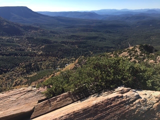
A typical scene from the Mogollon Rim southeast of Sedona, Arizona View (c) John Davis
Land— The Mogollon Wildway goes from the Gila backcountry’s modest elevations clothed in sunny pine forests, to Arizona’s tallest mountains, the oft snow-capped San Francisco Peaks, to our continent’s deepest incision, Grand Canyon. The Mogollon Wildway links the Gila wildlands complex with the Grand Canyon wildlands complex via the Mogollon Plateau and Rim. The Mogollon Rim comprises much of the southwestern edge of the vast and geologically superlative Colorado Plateau.
Wildlife– Thanks to heroic work from southwestern conservationists, the Gila backcountry is among the few places in the lower 48 states to have retained and regained its top carnivores. Against long odds, Fish & Wildlife Service released Mexican Wolves, Lobos, into the Gila wilds in the late 1980s. Despite persecution by some ranchers and gunners, Lobos have thrived in the Gila wildlands complex since then and have tried to expand their recovery. Pumas have survived centuries of persecution, and continue to play their essential browser-regulating role in the forests and grasslands and riparian zones of the Gila watershed. Coyotes, foxes, Bobcats, Badgers, weasels, Ringtails, snakes, and raptors also continue to play crucial stabilizing roles. Rare species here include Gila Trout, Gila Chub, Loach Minnow, Southwestern Willow Flycatcher, Least Bells Vireo, Mexican Spotted Owl, and Mexican Wolf.
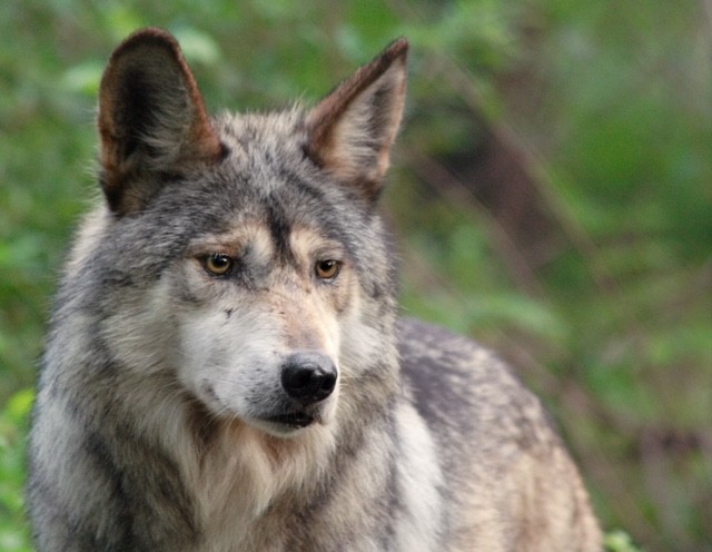
(c) Wolf Conservation Center
Lobos are attempting to disperse just as we would expect — and as we should welcome – northwest from their small official Recovery Area in the Gila and Apache National Forests of southwest New Mexico and southeast Arizona along the Mogollon Plateau and Rim toward the Grand Canyon. Several intrepid Lobo scouts have made the long journey, but they’ve been captured and returned to the small area where they are allowed. Politics, not biology, stands in the way of their recolonizing more of the Mogollon Wildway and regaining old strongholds across the Colorado Plateau.
Water– Springs are happily abundant but sadly degraded along the Mogollon Rim. They represent some of the “low hanging fruit” for future conservation efforts. The Springs Stewardship Institute is working throughout the Colorado Plateau and beyond with land-owners, land management agencies, tribes, and all who care about healthy waters and lands, to identify and conserve freshwater springs. Springs are hotbeds of biodiversity, providing habitat and/or sustenance to thousands of species, many of them endemic to a small number of springs.
Sadly, most springs in the US Southwest – and probably by now most worldwide, though few assessments have been done – have been damaged by livestock, logging, roads, mining, and other exploitive uses. Relatively simple measures can conserve the wildlife and water of springs, like fencing out livestock, creating no-cut buffers around them, and modifying culverts to afford natural water flow and aquatic wildlife movement.
The Mogollon Wildway is rich in springs – probably containing thousands, judging by Springs Stewardship Institute’s preliminary surveys — and many of these springs have rare and imperiled species. In particular, the Mogollon Rim north of Route 260 is rife with springs, enhancing its appeal to hikers and cyclists as well as making it ecologically critical. A hiker or gravel-biker can get a good sense of the Mogollon Rim’s profusion of springs by walking around the General Springs area, on either side of the Rim Road (FS road 300). Water runs in all directions, with freshets creating some of lushest meadows and forests one can find in Arizona. The springs from General Springs flowing south gather to form the East Verde River.
Streams, which are usually fed by springs, are equally critical ecologically and hydrologically; and again, the Mogollon Wildway is richly endowed. Arizona’s two designated Wild & Scenic Rivers, the Verde River and its tributary Fossil Creek, both head on the Mogollon Plateau, as do Oak, Sycamore, Wet Beaver, and West Clear Creeks. The Verde River forms a cottonwood-lined oasis in the high desert, popular with paddlers and vital to wide-ranging animals like Puma, Coyote, Ringtail, Javelina, deer, raptors, and songbirds, as well as to the fish and macro-invertebrates in its waters.
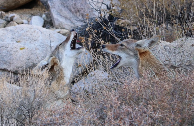
Siblings Singing
The White Mountains of Arizona, and particularly Mt Baldy (11,400’) collect much of the region’s moisture coming from the Gulf of Mexico or the Pacific Ocean, and are thus a major water source for the Southwest. Here are the headwaters of the Little Colorado, Salt, and San Francisco Rivers.
Farther southeast in the Mogollon Wildway is the watershed of the Gila River, a main artery of the Southwest, ecologically and hydrologically. The Gila and its main tributaries in southwest New Mexico and southeast Arizona, the Blue, San Francisco, and Mimbres Rivers, are home to rare fish, and have some of the healthiest riparian habitat in the West, thanks to remoteness, Wilderness Area designations, and partial removal of livestock from some sensitive habitats.
When assessments for potential Wolf recovery habitat were done years ago, the complex of small mountain ranges from the Blue Range Primitive Area through the Gila Wilderness ranked as outstanding, due to this being an exceptionally well watered part of the Southwest, and hence rich in prey for carnivores. For anecdotal comparison, John D saw on a typical day of bike-packing through the Gila and Apache National Forests about fifteen Javelina (Collared Peccary), twenty Mule Deer, much sign of Elk (but they were hiding, as it was rifle season), and a Sonoran White-tail Deer – all potential food for Wolves and Pumas (and then for the scavengers who follow them).
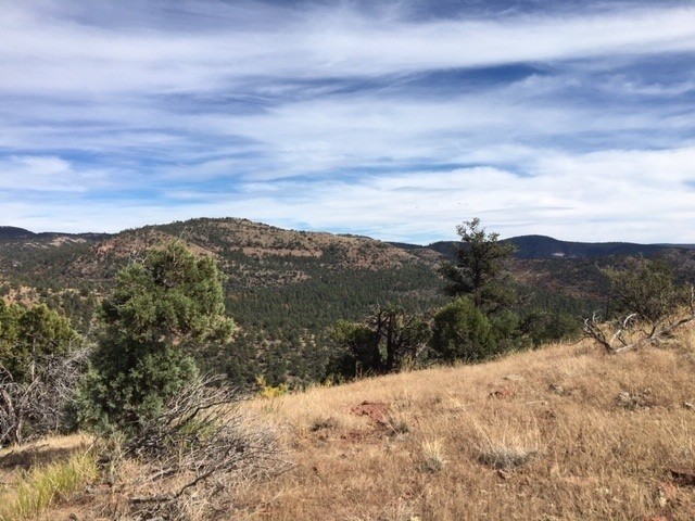
Looking south into the Blue Range Primitive Area from the Forest Service road on its north boundary (c) John Davis
Peoples– Like much of the Southwest, the Mogollon Wildway holds the homelands to many native tribes, all subjected to Euro-Americans displacing or killing them and restricting those who remained to small politically-defined areas. The Mogollon Plateau and Rim – which take their name from the Mogollon people, who long lived in this area — still have abundant cultural evidence and influence of the gatherer-hunter-grower tribes that preceded our agricultural-industrial civilization. Mimbres art, world famous now, originates from this area. Many museums, especially the Museum of Northern Arizona in Flagstaff, contain pottery, arrowheads, and other crafts from the peoples of this area; and visitors often find additional artifacts (and, if ethical, leave them in place).
Climate– In this century of climate chaos, habitat connections, especially altitudinal and latitudinal, become vital to the survival of sensitive and wide-ranging species. Running roughly southeast to northwest, and with elevations ranging from below 3000 feet to over 12,000 feet, the Mogollon Wildway – if we adequately protect it — will afford safe travel routes to cooler climes and relict micro-climates for species that otherwise might be doomed by anthropogenic global overheating.
Paths Therein– The National Forests and other public lands of Mogollon Wildway are already liberally sprinkled with trails and scarred with roads, but connecting them into a National Scenic Trail and a bike-pack route is requiring much scouting and map study, some of which has happened during the Grand Canyon Wolf Recovery Project’s Paseo del Lobo outings, and some during TrekWest and follow-up trips. Basically, the Lobo Trail can use and connect a southern part of the Continental Divide Trail near Silver City with a northern part of the Arizona Trail to South Rim. Most of it between these two great thru-trails, too, can follow shorter existing trails, and for bike travel, lightly used roads.

Sights and Sounds Along the Mogollon Wildway
Collectively, in our explorations of the Mogollon Wildway, we have had countless wonderful experiences with wildlife, waterways, and weather. A few personal anecdotes help illustrate what a back-packer or bike-packer may experience here:
Mogollon Baldy, a high-point in the Gila Wilderness, at 10,750 feet, and often snow-shrouded, shimmers in bright summer sun and swarming orange lady-bug beetles.
A stunningly beautiful Red-faced Warbler sings from atop a cottonwood tree in a riparian forest of the Mimbres River.
From the heart of America’s first designated Wilderness Area, the Gila, howls a pack of Lobos, released in the area Aldo Leopold helped protect, after his Green Fire epiphany of a century ago, in which his watching the fierce green fire dying in the eyes of a Wolf he’d just shot made him realize the mountains want Wolves.
An American Dipper, or Water Ouzel as John Muir preferred to call this marvelous underwater-diving songbird, flies quickly from the rapids of the Middle Fork Gila River to her nest under a rock overhang above the water.
Gila Trout lurk in the shadows of the West Fork Gila, occasionally darting for flies that alight on the shining waters.
Trails in the heart of the Gila Wilderness, remote from human exploitation, are liberally strewn with scats of carnivores, including Bobcat, Puma, Gray Fox, Lobo, Black Bear, and weasels.
A big dark object moving through the pinyon-juniper woodland across the San Francisco River resolves itself into a foraging Black Bear.
Two hikers watch the sun set and full moon rise from atop Loco Peak. Walking back to their tents afterward, they are followed at a respectful distance by a curious Puma.
A whiptail scorpion big as a mouse walks ponderously down to the Blue River.
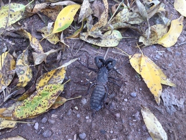
A whiptail scorpion, or vinegaroon, nearly three inches in length, heads down toward the Blue River (c) John Davis
An extended family of ten Javelinas, including several darling little ones, scurries out of sight into the willows along Dry Blue Creek, as they hear the bicycle approach on the dirt road above.
The deeply incised Black River flows steadfastly past that famed Green Fire site, decade after decade of serving the whole biota, from Wolves to warblers.
Lush meadows amid aspen stands, soon to be spangled in wildflowers, emerge slowly from melting spring snow on the flanks of Mt Escudilla, where roamed the last known Grizzly Bear in Arizona.
Coyotes answer either the full moon or the bugling Elk in the fall rut north of the Mogollon Rim, as a light freeze frosts the ground.
Into the grand old-growth Ponderosa Pines of McKenna Park disappears a herd of Elk. Nearby, a Bobcat flits in and out of the shadows cast by the great tree trunks.
In autumn, the San Francisco Peaks become grandly though distantly obvious, even from a hundred miles south across the vast Mogollon Plateau, when snow brightens their summits.

A tarantula crosses the Rim Road, urged on by a concerned bicyclist. Male trantulas are often moving in autumn, looking for females. (c) John Davis
A black male tarantula walks boldly across the Rim Road; as a bicyclist watches with awe, then hastens the spider’s crossing, to ensure he not get hit by a passing vehicle.

A horned lizard basks in autumn sun below the Mogollon Rim and above Tonto Creek (c) John Davis
A horned lizard, short and squat, suns itself on a sandstone slab, mid-way down the Mogollon Rim escarpment, not far above lush Tonto Creek, on a warm autumn day.
A young Badger, perhaps unacquainted with people, can’t quite decide whether to run from a hiker or investigate this strange tall two-legged thing, but finally decides caution is the better part of valor and trundles away from the trail.
Elk heavily trot and Pronghorn lightly bound away from a lone hiker following the Arizona Trail across Anderson Mesa, toward Flagstaff.
Conclusion– Lobos, Pumas, Black Bears, weasels, raptors, trout, chubs, lizards, snakes, flowers, trees, back-packers, horse-packers, and bike-packers deserve safe ways to move between the two greatest wildlands complexes in the Southwest, the Gila and the Grand Canyon. The Mogollon Wildway is that link, and it is still relatively intact, but faces many ongoing threats, including inappropriate, tax-payer subsidized livestock grazing and logging on public lands and housing sprawl on private lands. Increased public support is needed to keep the Mogollon Wildway safe for wildlife movement and habitation. A National Scenic Trail and companion bike-pack route can help raise the profile of this little-known yet gorgeous area, and generate momentum for its greater conservation. We’ll know we’ve done our job well here when anywhere along the Lobo Trail, after a long day of admiring wildflowers and songbirds and Puma scrapes, we can fall asleep in our tents to the musical howls of nearby Wolf families.
________________________________________

Kelly Burke
Kelly Burke serves as Executive Director for Grand Canyon Wildlands Council, which she cofounded with Kim Crumbo and ecologist Dr. Larry Stevens in 1996.
She has 14 years’ experience in geological mapping, including extensive trips on the Colorado River to advance ecological research and riparian restoration. Kelly has led natural history tours in Grand Canyon, Zion, and Bryce National Parks, and also in Alaska, and has published scientific articles about structural geology, geomorphology, and geochemistry of natural waters. In 2016, Kelly initiated the Conservation in Motion program to bring together conservationists, scientists, artists, adventurers and outdoor-brand athlete ambassadors in the campaign to permanently protect the lands embracing the north and south rims of Grand Canyon. She lives at the foot of the San Francisco peaks in Flagstaff, where she tries to weave horseback riding and time in the wild with her terrier mix, Georgia, into every reasonably nice day.

John Davis serves as wildways scout, editor, interviewer, and writer for the Rewilding Institute. He also works as a rewilding advocate for the Adirondack Council, a member-supported group defending the ecological integrity and wild character of New York’s great Adirondack Park. John serves on the boards of RESTORE: The North Woods, Eddy Foundation, and Algonquin to Adirondack Conservation Collaborative. He previously was editor of Wild Earth and worked for the Foundation for Deep Ecology. In 2011, John completed TrekEast, a 7,600-mile muscle-powered exploration of wilder parts of the eastern U.S. and southeastern Canada. In 2013, he trekked from Sonora, Mexico, north along the Spine of the Continent as far as southern British Columbia, Canada, ground-truthing Rewilding North America and promoting habitat connections, big wild cores, and apex predators.