

Scouting locations for wildlife crossings in the Adirondacks, Part Two
September 26, 2019
Featured image: Bobcat © MasterImages
By Kevin Webb
In Part One, we covered wildlife crossings, and what ecological services they could perform in Adirondack Park. This time, we’ll highlight some best practices from Banff National Park in Canada, and use these to suggest some potential locations for wildlife crossings in the Adirondacks.
The highway crossings of Banff
Dissecting the Rockies and Canada’s Banff and Yoho national parks is the Trans-Canada Highway (TCH), an east-west roadway that fragments important north-south migratory routes for deer, bison, elk, bears, wolves, and more. In the late 1970s, plans began to “twin,” or add second lanes to, much of the highway to accommodate increased traffic levels; already, Banff saw over 100 accidents per year caused by deer and elk, and designers were concerned that with increased traffic this would worsen, and might further interfere with the animals’ migratory behaviors.
Because the TCH is managed within the parks by Parks Canada, which includes wildlife welfare and visitor experience as core mandates, planners secured funding to build wildlife-exclusionary fencing along the highway through the parks, along with a series of underpasses and overpasses to facilitate animal movement. Construction began in 1983, and, as of 2013, there were 6 overpasses and more than 40 underpasses, all of which have seen use by animals. These crossings have become miniature corridors that connect habitats on both sides of the highway.
Key Lessons from Banff
With over 30 years’ experience in building and testing these new wildlife crossings, conservationists from Banff are now consulted globally for their expertise. The following highlighted learnings are drawn from published articles and personal correspondence with Trevor Kinley, an environmental assessment scientist with Parks Canada’s Highway Engineering Services (Clevenger et al.; Dickie; Kinley; Bissonette et al.).
Prioritize East-West Highways
By focusing on east-west highways, planners can typically see a higher conservation return on investment (ROI), as these highways bisect natural seasonal migrations; and facilitating movement in a south-north direction will help animals adapting to warming climates.
Build fencing fully
A hard lesson has been the need to construct fencing fully between over- and underpasses; animals are often wary of these new means of crossing highways, and may choose to run across highways wherever they see a break in fencing. This becomes particularly dangerous to animal and motorist alike when they panic; should they flee back from the road, they will often be too confused and stressed to be able to navigate back through the fence.
Further fence-related precautions at Banff now include a top-mounted wire, to better ensure the fence stays upright when trees are downed in inclement weather, and adding chain link fence belowground to prevent digging by carnivorous animals. Generally, fences should be located as close to roadways as possible, to ensure animals can see and smell the other side of the road.
Build underpasses and overpasses
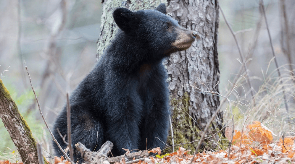
Cheap and unobtrusive, underpasses do the majority of work in Banff, and are the preferred crossings for black bears, mountain lions, and smaller animals like reptiles and amphibians. They can be assembled relatively quickly using prefab concrete culvert materials.
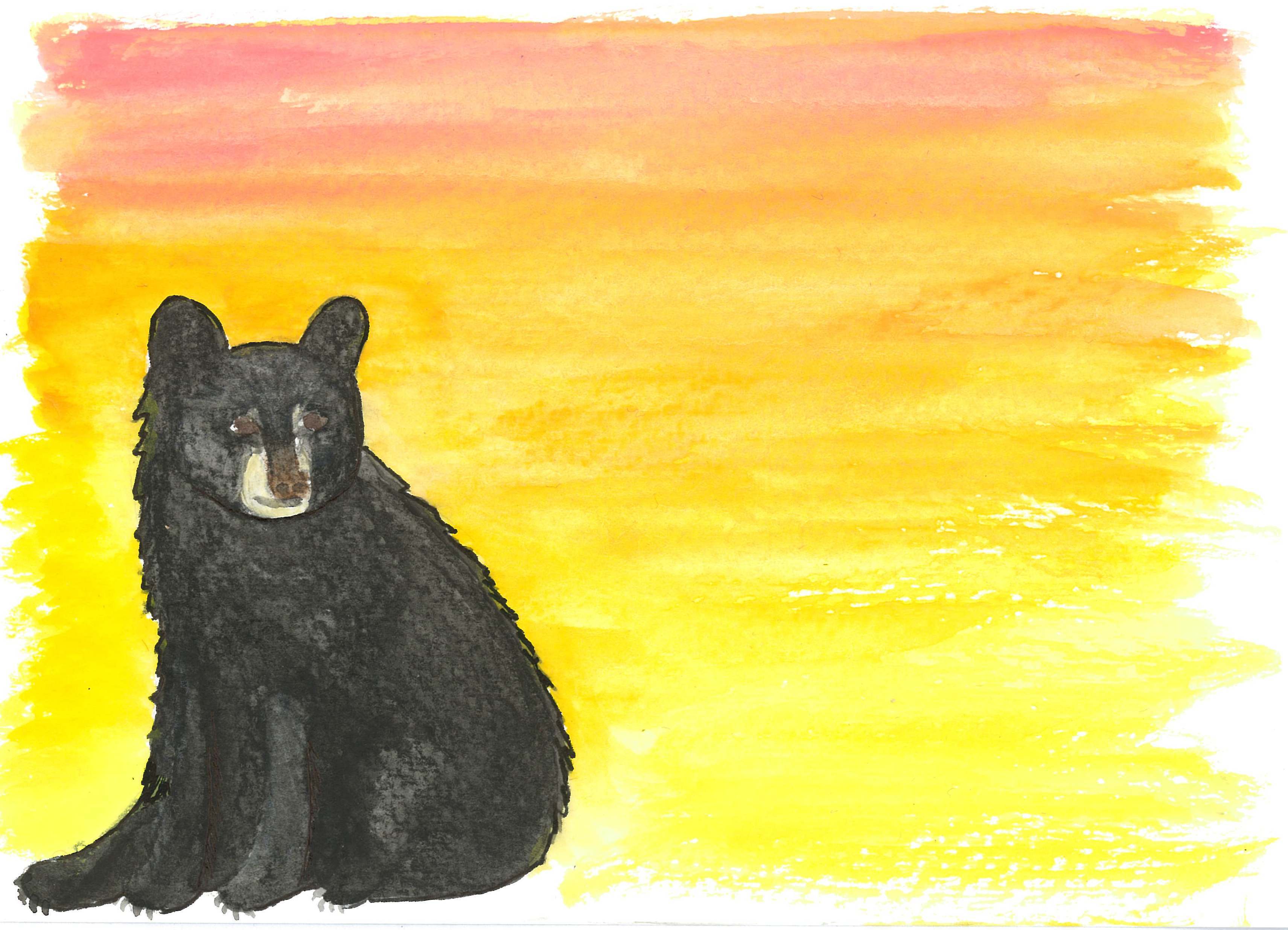
American Black Bear © KIT West Designs
Overpasses, meanwhile, are underpasses’ charismatic, costlier cousins. Built in much the same way a bridge might be, they can be planted with natural vegetation which helps lessen the noise from the highway below. They are the preferred path for ungulates and grizzly bears, which seem to prefer clearer sightlines.
Use features of the land
A key mistake for designers is over-optimizing locations of corridors for where animals presently attempt to cross roads, or where vegetation suggests an ideal site. Instead, designers should focus on “constructible” sites, where building an overpass or underpass is facilitated by the characteristics of the land. An overpass, for example, is simpler to build and more likely to be used where a road already runs beneath land on either side; an underpass may be better installed where a roadway is already elevated. Many locations are poorly suited for either type of construction, but animals in Banff will dependably move to reach a crossing site.
Prepare for maintenance
In Banff, securing financing for new projects, particularly underpasses, has been relatively straightforward, as these projects tend to be popular and the public safety benefit is fairly clear. Maintenance, however, remains an ongoing concern; with these projects, highway workers must maintain miles of fencing against poor weather, animals, and car accidents, as well as overpasses that must work both as manmade projects that ensure driver safety, and as wildlife-friendly corridors.
Scouting Wildlife Crossings in the Adirondacks
In this report, we highlight and discuss three potential highways within or near New York’s Adirondack Park that could be suitable for the construction of wildlife crossings. This assessment is based on police-reported, animal activity-caused traffic accident data for the twelve counties that make up the Adirondacks. Municipality-level data were combined for the 10-year period from 2009-2018, to yield a very rough approximation of where human-animal collisions were most frequent, and where they were most likely to result in personal injury or death (New York State Crash Data by County and Municipality. Crash Contributing Factors: Animal Action. 2009-2018. Counties of Clinton, Essex, Franklin, Fulton, Hamilton, Herkimer, Lewis, Oneida, Saratoga, St. Lawrence, Warren, Washington.). Data was then mapped using QGIS open-source software. As might be expected, these stretches tend to fall in between desirable habitats, where humans are likely to drive at sufficient speeds to cause damage. Notably, all three target highways have more wildlife-vehicle collisions per year than Banff did when construction began there.
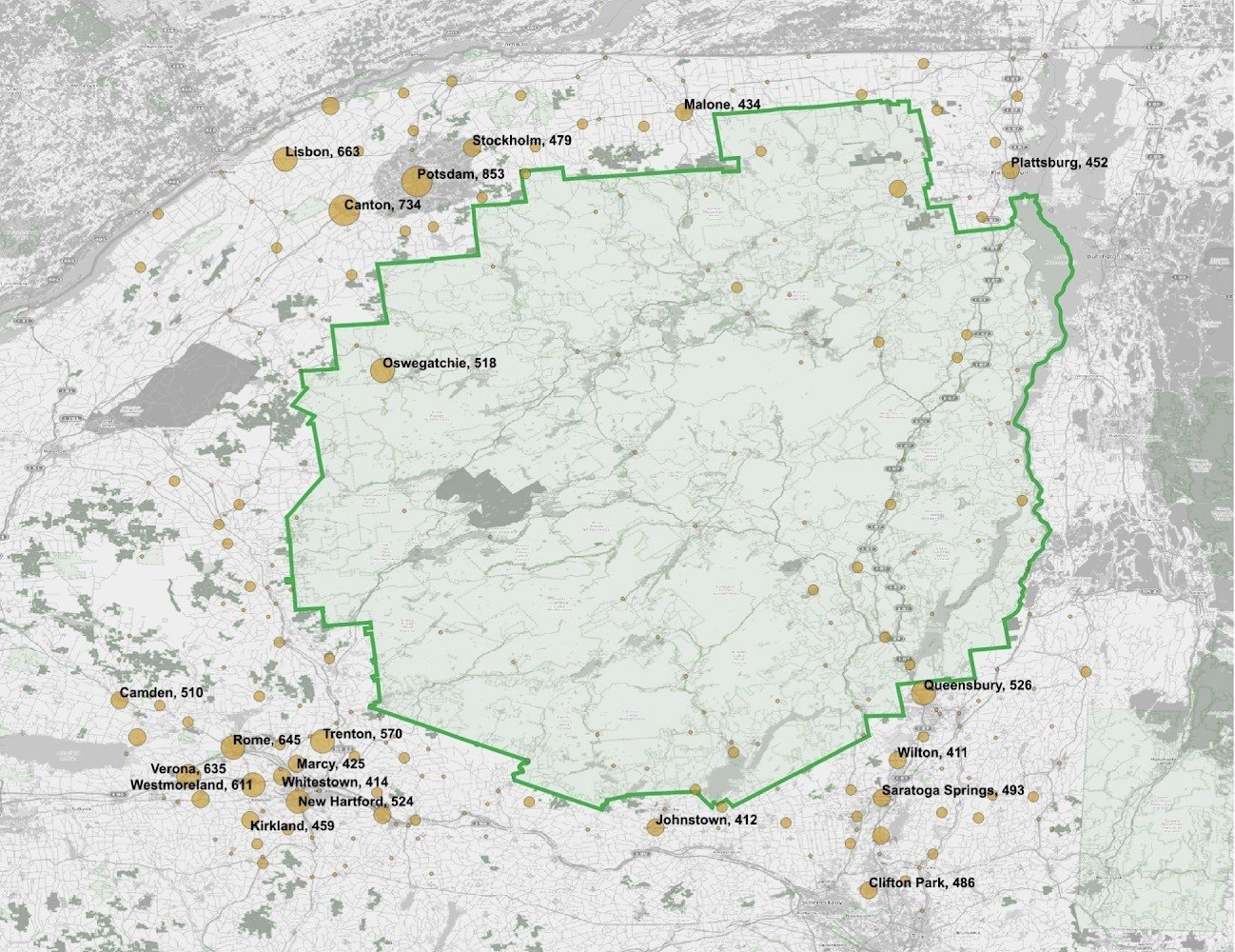
Figure 1: Animal-caused accidents by municipality for the 12 counties that contain part of Adirondacks Park, 2009-2018. Data compiled from ITSR and plotted via QGIS. Park boundary is denoted by the green line © Kevin Webb
Target Site 1: I-87

Figure 2: A proposed stretch of I-87 for erecting wildlife-exclusionary fencing, overpasses, and underpasses. Blue line denotes I-87 from north of Albany to Lake George. Municipalities and animal-caused accidents from 2009-2018 are listed © Kevin Webb
Assigned in 1957, Interstate 87 is one of the most trafficked highways in America, and serves not only as the entry for most visitors to the Adirondacks, but as the primary economic thoroughfare between New York City and Montreal. It serves approximately 80 million people throughout New York, the mid-Atlantic states, and Montreal (Harbour).
Although I-87 is a south-north route, the Wildlands Network has nonetheless identified the Southern Lake Champlain Valley as a key linkage to create a wildlife corridor that stretches from Florida to Maine. By connecting New York’s Adirondacks Park to Vermont’s Green Mountains and to other forests of the Northeast, it could become easier for species like moose to move between regions (Davis).
One key thematic benefit for the I-87 route is its prominence; with the creation of wildlife overpasses, civic planners could showcase the Adirondacks’ “Forever Wild,” shared landscape values with all who pass underneath. Logistically, due to its location near New York City, the movement of construction materials could be relatively inexpensive compared to the other sites considered.
Construction around I-87 could initially focus on the 55-mile stretch from just north of Albany to the southern end of Lake George, which would encompass the sites of Queensbury (526 animal-caused traffic incidents reported between 2009-2018), Wilton (411), Saratoga Springs (493), and Malta (385). Some of these cities also touch US Route 9, which is a smaller highway running roughly parallel with I-87 and a second source of road mortality. Ideally, construction of safe wildlife crossings would eventually continue northward to Lake Champlain and beyond.
The selection of this southerly portion of I-87 would bring with it drawbacks. As the largest, most trafficked highway of any of those proposed, construction is likely to be disruptive, and manufacturing will be made more expensive by the need to span 6 lanes, rather than two or four. Indeed, even if built, this long width may prove a deterrent for wild animals who might otherwise consider crossing. Further, due to its close parallel with US 9, it may become necessary to build crossings along that highway as well. Lastly, the higher frequency of collisions with animals in this region may owe more to the higher amount of traffic on this leg of the highway than to the ecological value of wildlife crossings there. For maximal ecological impact, it may be wise to instead erect crossings and fencing on the stretch of I-87 within park boundaries, even though fewer collisions would be prevented there.
Target Site 2: US Route 11
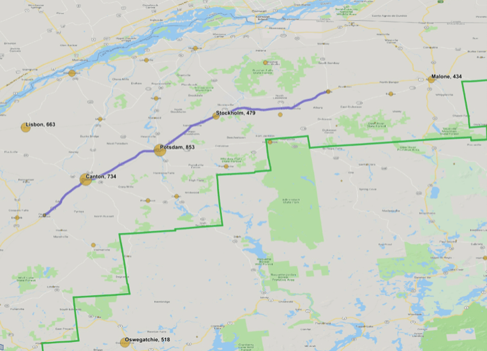
Figure 3: A proposed stretch of US 11 for erecting wildlife-exclusionary fencing, overpasses, and underpasses. Blue line denotes US 11 from north of De Kalb Junction to Moira. Municipalities and animal-caused accidents from 2009-2018 are listed © Kevin Webb
Designated in 1926, US Route 11 hugs New York’s northern boundary, where wildlife may seek to cross from near the St. Lawrence River, before hooking southwest as it moves toward the state’s border. A potential project could focus on a 44 mile stretch from De Kalb Junction through Moira. This would transect three of the most accident-prone sites in the studied region, per data from 2009-2018: Canton (734 reported animal collisions), Potsdam (853), and Stockholm (479). Extended 21 miles further to Burke, the project could also include Malone (434 animal-caused collisions).
As a lower-trafficked site, this highway may present advantages in ease of construction, and importantly, this stretch corresponds with where there are only presently two lanes, which would reduce cost of construction and present shorter, more attractive paths for animals to migrate from one side to the other. Because the route moves east-west, it would be well-suited for aiding animals’ natural migration patterns north-south, as well as facilitating any new climate-related movements.
Commerce advocates from the region have discussed replacing or supplementing US 11 with a new, larger highway to support industry in the region, which has sometimes been referred to as Highway 98 or the Rooftop Highway. While the construction of such a project would doubtless interfere with animal crossings, and is opposed by most wildlands proponents, it may if approved present an opportunity to include wildlife crossings as part of its scope, similar to how the construction of Banff’s crossings were tied to new road twinning. More modest plans to add passing lanes to parts of US 11 (an alternative preferred by conservationists) could similarly be coupled with adding under- or overpasses, along with fencing.
Drawbacks of this site include its far-northern placement, which would increase transportation and construction costs, and which may make finding construction workers more difficult. Additionally, it receives fewer tourists than the other two sites, which may reduce the cultural value of construction.
Target Site 3: Interstate 90
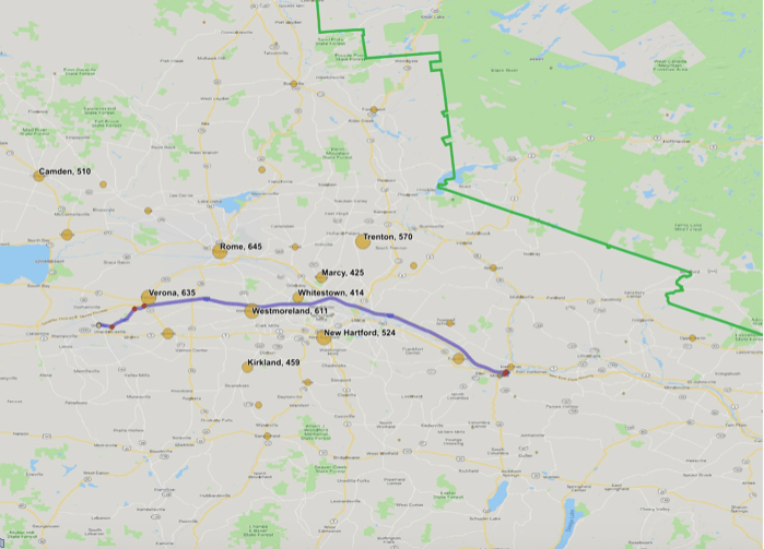
Figure 4: A proposed stretch of I-90 for erecting wildlife-exclusionary fencing, overpasses, and underpasses. Blue line denotes I-90 from Oneida to Mohawk. Municipalities and animal-caused accidents from 2009-2018 are listed © Kevin Webb
Along the Adirondacks’ southern border is Interstate 90, a 386-mile highway that connects from Pennsylvania to Massachusetts. A potential stretch suitable for adding fencing and crossings is the 33 miles from Oneida to Mohawk. This would include Verona (635 animal-caused accidents between 2009 and 2018), Westmoreland (611), Whitestown (414), and Frankfort (394).
While this proposed stretch could be lengthened with time, future capital near the proposed I-90 site may be better spent on adjacent State Routes, as nearby cities with larger accident rates include Rome (645), New Hartford (524), Trenton (570), and Marcy (425). Taken together, it seems that wildlife travels southwest to northeast toward the Adirondacks, and that the larger human population outside the Park increases the probability of accident.
Ecologically, this site is valuable for its east-west alignment, and for connecting the Adirondacks to the interior of New York, where activities like hunting are a significant regional pastime. However, its proximity to larger populations of humans may make it unlikely to add biological diversity to the Adirondacks, and it may increase human conflicts with species like coyotes and bears.
Economically, I-90’s shorter length, four lanes, and access to larger cities and thus potential workers may make construction costs somewhat moderate compared to other proposals. Its location between neighboring states, and above larger rural populations to the south, may ultimately yield some of the cultural value of I-87’s proposal.
Drawbacks include its potentially lowered ecological value, the need to work on additional nearby state routes, and the risk of unwanted, increased human-animal interactions.
Other possible locations for safe crossings
In addition to entire stretches of highway, regional wildlands advocates like John Davis have identified, but not yet thoroughly studied, specific sites for wildlife crossings (including modified culverts) across other busy road stretches in or around Adirondack Park. These include:
- I-87 where it fragments Split Rock Wildway, likely where it passes over the North Branch of the Boquet River
- Route 3 in the northwest Adirondacks, where it bisects the Algonquin to Adirondack (A2A) connection
- I-90 and I-88 where they cross over Schoharie Creek, which may be the least fragmented link between Adirondack Park and Catskill Park to the south
- Route 12 and other major roads that bisect the Adirondack to Tug Hill link
- Route 22 and other roads that bisect the Southern Lake Champlain Valley link between New York’s Adirondacks and Vermont’s Green Mountains.
For some road stretches, Adirondack Nature Conservancy, Wildlands Network, AuSable River Association, and other conservation groups have already had some success at working with departments of transportation on road and culvert modifications that enhance permeability for wildlife. In general, though, New York could do more to make its roads safe for the wildlife that need to cross them.
American Black Bear (Ursus americanus), cub © Master Images
Anticipated Overall Benefits and Drawbacks of Crossings
With any of the above potential locations, there could be several additional benefits, as well as unwanted consequences, to the ecology and economy of the region. Among these are:
Innovation
In a fragmented world, wildlife crossings are becoming an increasingly important conservation tool to maintain biodiversity, without forfeiting human economic needs. While Banff remains the global leader in implementing crossings, more expertise and innovation is needed to reduce costs of construction and increase the structures’ appeal to wildlife. With one of the world’s largest concentrations of architects, academics, and outdoor experts, New York could be well-positioned to pilot approaches and structures that could, in turn, be used globally. There may further be opportunities to use tools from civil engineering projects in New York City, such as used tunnel boring machines, to make construction minimally disruptive. Ultimately, the region of the Adirondacks could build on its environmental legacy to become a globally important center of building for the needs of humans and animals alike.
Economic activity
As with any major infrastructure project, construction along any of these sites would lead to new jobs for designers and laborers, as well as ongoing new jobs focused on maintenance, research, and public outreach. There would also likely be a benefit to the local tourism economy, due to the novelty of the structures, and to any resultant increase in wildlife density and diversity, which could make the region more enticing to visit. For hunters, preventing the loss of more wildlife will mean larger, healthier populations of deer, elk (if reintroduced), moose (though so far their numbers in New York are too low to allow hunting), and other prey species. Lastly, as a rural region with an aging population, any source of new economic activity could help slow or reverse demographic trends.
Reintroduction of predators and ecological benefits
With larger, more connected habitats, the Adirondacks would become even more hospitable to predator species than it already is, which may facilitate the natural or human-assisted reintroduction of keystone predators like mountain lions or wolves. If allowed to return to their historic ranges, these species would prey on weaker, more disease-prone herbivores, which could in turn reduce numbers of ticks, and improve the health of forests. Reductions in the incidence of tick bites would reduce the costs of diagnosing and treating Lyme disease, which would have a positive economic impact for residents and tourists alike.
Adverse consequences
As with any plan, construction of highway crossings would come with tradeoffs and drawbacks. Most significantly, any construction project of this scale would incur significant expense at its outset, as well as ongoing costs for maintenance. While there are economic benefits to curtailing accidents, the expense of corridor construction would be borne by the taxpayer, while the costs of accidents are generally borne by the individual. Additionally, success of this plan may lead to an increase in unwanted human-animal interactions, which could negate the positive population impacts of connecting habitats. Lastly, there could also be a loss in aesthetic value along highways, as these projects would require miles of wildlife-exclusionary fencing.
Conclusions
Wildlife crossings are a well-studied concept, but we still have much to learn about how best to create and maintain them. In the span of centuries, Americans have completely reshaped our landscape, and broken up historically connected ecological regions. No wildlife crossing should be expected to undo these actions. Yet, if there is any place to experiment with how we can build infrastructure to serve the needs of humans and wildlife alike, it just may be New York’s Adirondack Park and surrounds. With a high incidence of human-animal collisions, rising rates of Lyme disease, and tourism as a primary economic source, the expense of constructing wildlife-exclusionary fencing and over- and underpasses is easier to justify here than elsewhere. Perhaps more importantly, though, such projects would reflect in concrete the true ethos of this ecologically distinct region, which has spent over a century balancing the needs of humanity with those of nature.
____________________________
Works Cited / Works Referenced
Bissonette, John A., et al. Evaluation of the Use and Effectiveness of Wildlife Crossings. National Academies Press, 2008. DOI.org (Crossref), doi:10.17226/14166.
Clevenger, Anthony P., et al. Banff Wildlife Crossings Project: Integrating Science and Education in Restoring Population Connectivity Across Transportation Corridors. Parks Canada Agency, 11 June 2009.
Davis, John. “Eastern Wildway – The Essential 16.” Wildlands Network.
Dickie, Gloria. “As Banff’s Famed Wildlife Overpasses Turn 20, the World Looks to Canada for Conservation Inspiration.” Canadian Geographic, Dec. 2017, p. 7.
Harbour, Parsons-Clough. I-87 Multimodal Corridor Study. New York State Department of Transportation, May 2004.
Kinley, Trevor. Planning Wildlife Crossings in Canada’s Mountain Parks. International Association for Impact Assessment, 13 May 2013.
New York State Crash Data by County and Municipality. Crash Contributing Factors: Animal Action. 2009-2018. Counties of Clinton, Essex, Franklin, Fulton, Hamilton, Herkimer, Lewis, Oneida, Saratoga, St. Lawrence, Warren, Washington. Institute for Traffic Safety Management and Research, . Accessed 8 May 2019.
A transplant to New York City, Kevin Webb grew up in the San Francisco Bay Area, where he worked as an early-stage software investor for the better part of a decade. Kevin recently completed a master’s degree in Sustainability Science at Columbia, and as an undergraduate at Stanford studied Human Biology with a concentration in humans, a changing environment, and infectious disease. Kevin’s interests include natural history, biology, comedy, making things, and spending as much time as possible with his dog Chewie. (His website: ktfoundry.com)